Wombarra Training Centre
BRIEF
Mr & Mrs Watson approached me to design for them a training facility for 18-20 people, where they could provide accredited instruction (via lecture, film and video presentations, tutorial sessions and on-site practical exercises) in OH&S, confined space activities, HAZCHEM procedures and emergency scenarios.
I was alerted to the necessity of students being able to directly apply the theory studied in the classroom to (as near as possible) real life situations, whilst these concepts are still fresh in the mind.
The client needed to incorporate managers accommodation, as both the site
and expensive equipment used, will need security on site, outside of operating
hours.


APPROACH
The site is a 24.5 Ha parcel of land stretching from the railway in the
East to the Escarpment top in the West. Since its use as a colliery lapsed,
substantial work was undertaken by State Rail to provide a flood mitigation
bunker and stormwater tunnel that empties out at Scarborough Beach. During
this time restrictions as to use and easements were created, over the flatter
section immediately adjacent to the main gates.
The topography is generally as follows: Adjacent to the main gates is a
large concrete bunker (approx.8m x 6m), situated on a gently sloping area
that extends as a strip along the Eastern boundary (shared by the railway).
A levee bank and a concrete topped tunnel extending the width of the property
largely dominate this area.
Approximately one third away from the Eastern boundary, a road meanders
from the front gates to the opposite boundary. This road is concrete from
the gates to the bunker, then bitumen to a large grassed plateau (approx.
175m wide by 63m deep), about two-thirds from the Southern boundary. The
road then continues as an unsealed service track to the boundary and beyond,
and is currently in use to maintain electrical cables, etc.
The land generally has a slope of about 30°, from the flat strip near the
Eastern boundary to the road, and from there, increases into the Escarpment
proper.
A smaller plateau (approx. 80m x 25m) rests about 12m lower and south of
the larger plateau. At the southern end of this plateau is a substantial
retaining wall, including within it the entrance to a disused conveyor maintenance
tunnel.
A dirt track runs from the northeastern end of the plateau down to the tunnel
entrance, and then turns back on itself down to a railway maintenance road
at the end of the levee bank.
A dam (38m wide x 50m long) lies adjacent to the southern boundary, approximately
one-third from the eastern boundary. The dam wall has an outlet with a stop
valve that can be used for a static water supply, in case of fire.
Location:
Upon inspection of the site three possible of locations were selected. The
most obvious location ended up being the most suitable.
The site is zoned both 7a and 7b, with the separation being approximately
along the line of the roadway; the upper portion being zoned 7a.
The large flat area adjacent to the gates, whilst being the location of the
office buildings when it was a colliery, is in fact too close to neighbouring
properties to now use as a site. Under closer scrutiny, this whole area is
subject to a restriction of use for stormwater purposes, and is consequently
unsuitable as a site.
Similarly, the larger plateau, being contained within the 7a portion, is
unsuitable for building; yet, it provides an ideal space for training purposes.
The remaining, smaller plateau is the ideal location. It is contained within
the 7b portion, and it is devoid of any significant vegetation so no clearing
is necessary. It has room for a good-sized centre, twenty-two car-parking
spaces, a bitumised access road and an emergency access track in the other
direction. Also, adjacent to the car park is the entrance to the disused
conveyor maintenance tunnel, one of the unique facilities on the site to
be used for training.
The larger plateau nearby is perfect for trialling hazardous materials control
and decontamination exercises. It is also good for a portable field hospital,
etc.
At the end of the bitumen road is the flood mitigation bunker, which would
be useful for setting up rescue scenarios, without even entering the bunker
or tunnel.
The substantial vegetation between the plateau and railway gives a screening
to the project so it will not be visible from neighbouring properties.
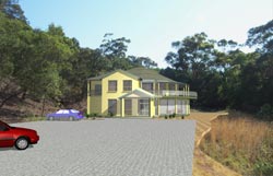
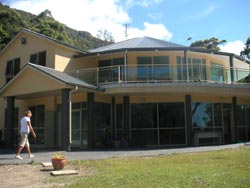
Design:
A double storey building was chosen to minimise the footprint of the building
on the plateau, thereby maximising the parking and landscaped areas
Directly above (behind) the proposed location is a semi-circular projection
in the escarpment; the design of the building is hemispherical in form to
mirror this projection.
The profile of the land is steeply sloping with steps and layers; therefore,
the balcony and roof are to step back in sections, following the topography
of the land.
As the client had five children under ten, the residential component needed to
incorporate six bedrooms, which meant the accommodation would necessarily occupy
a sizable portion of the project overall. The orientation of the entrance to the
staff quarters was purposely concealed from the car park to ensure the true purpose
of the centre remained unarguably apparent.
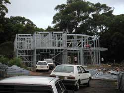
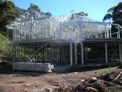
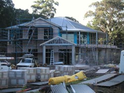
RESULT
After two years in Council, answering a multitude of queries during the DA process, in 2004
the building was constructed with a minimum of fuss, and to a high standard. The training centre has been operating successfully ever since.